Neighbouring Countries Of India – India and it’s Neighbourhood
Are you ready for UPSC Exam? Check your preparation with Free UPSC Mock Test
The Republic of India lies in the northern and eastern hemisphere between latitudes: 84′N and 37°6’N and longitudes: 68°7′ E and 97°25′ E. It is situated in Southern Asia and is divided by the Tropic of Cancer 23°30′N in almost two equal parts.
The country has an area of 3.28 million square km accounting for 2.4% of the world’s area. It has a land borderline of 15200 Kms and a coastal borderline of 7516 Kms. It has 29 states and 8 Union Territories. The population of the country is 135.26 crores.
7 major rivers i.e. Indus, Brahmaputra, Narmada, Tapi, Godavari, Krishna, and Mahanadi along with their numerous tributaries make up the river system of India. The water bodies surrounding the peninsula include:
- Arabian Sea to the west.
- Bay of Bengal to the east.
- Indian Ocean to the south.
- The Himalayan mountains border the nations of China, India, Pakistan, Nepal, Bhutan, and Afghanistan.
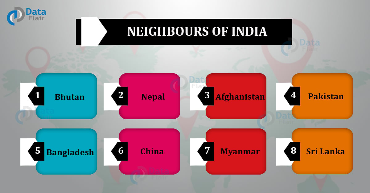
The neighbouring countries of India include:
- China to the northeast.
- Bhutan to the northeast.
- Nepal to the north.
- Afghanistan to the northwest.
- Pakistan to the northwest.
- Bangladesh to the east.
- Myanmar to the east.
- Sri Lanka to the south.
- Maldives to the south.
More About The Neighbouring Countries Of India:
China
The people’s republic of China is a country located in East Asia. It is the world’s most populated country. It is a developing country according to the World Bank.
China has been among the world’s fastest-growing economies, with real annual gross domestic product (GDP) growth averaging 9.5% through 2018. It is the second-largest economy in the entire world and has the third-largest army across the globe.
Though there have been efforts to maintain peace between India and China, disputes such as the Sino-Indian border dispute, Galwan Valley conflict, and the military standoffs of 2020 have strained their relations.
Capital: Beijing.
Currency: Renminbi (Of Which Yuan Is A Unit).
Official Language: Mandarin.
Total Area: 9.597 million km².
Borderline Length: 4056 Kms.
States/Provinces: 34.
National Animal: Chinese Dragon.
Flag Colour: Red, Yellow.
Population(2020): 143.93 crores.
Government(2020): Communist Party of China.
Bordering Countries: Afghanistan, Bhutan, India, Kazakhstan, North Korea, Kyrgyzstan, Laos, Mongolia, Myanmar, Nepal, Pakistan, Russia, Tajikistan, and Vietnam.
Bhutan
The kingdom of Bhutan is a non-coastal country in South Asia. It is famously known as the Buddhist kingdom which is located on the eastern edge of the Himalayas.
It has a slow rate of development, despite having top economic freedom, an encouraging environment for business and almost no corruption. The real annual gross domestic product (GDP) growth average of Bhutan was 3% through 2018.
India and Bhutan share bilateral ties, which also somewhat influence the commerce policies of the country. Bhutan and India have a deep historical and cultural connection.
The amendment of the 1949 – Treaty of Peace and Friendship in 2007 led to the independence of Bhutan in terms of foreign and defense affairs.
Capital: Thimphu
Currency: Bhutan Ngultrum
Official Language: Dzongkha
Total Area: 38394 Km²
Borderline Length: 1136 Kms
States/Provinces: 20
National Animal: Takin
Flag Colour: Yellow, Orange, White, Black
Population(2020): 7.71 Lakhs
Government(2020): Druk Nyamrup Tshogpa
Bordering Countries: China, India
Nepal
The federal democratic republic of Nepal is a country in South Asia. It is situated across the Himalayan Mountains and the Indo- Gangetic plains. It contains 8 of the 10 highest mountain peaks in the world which also includes Mount Everest – the world’s tallest mountain peak.
Nepal has a low growth rate of development. The real annual gross domestic product (GDP) growth average of Nepal was 6.7% through 2018. Nepal and India share a relation of friendship and cooperation.
Due to an open border system, there is a wide connection of culture between the people of the two countries. The 1950 Indo- Nepal Treaty of Peace and Friendship compliments this. These two countries also share bilateral trade relations.
Capital: Kathmandu.
Currency: Nepalese Rupee.
Official Language: Nepali.
Total Area: 147516 km².
Borderline Length: 3104 Kms.
States/Provinces: 7.
National Animal: Cow.
Flag Colour: Crimson Red, Blue, White.
Population(2020): 2.91 crores.
Government(2020): The Nepal Communist Party.
Bordering Countries: China, India.
Afghanistan
The Islamic Republic of Afghanistan is a landlocked country at the junction of central and south Asia. It consists of a lot of plains, deserts, and mountainous regions. It has about $1 trillion worth untapped mineral deposits.
Afghanistan has a low development rate. The real annual gross domestic product (GDP) growth average of Afghanistan was 1% through 2018. Afghanistan and India share a strong historical and cultural link.
In 2011 both the countries signed a strategic partnership agreement, strengthening their bonds. This is further complemented by the frequent meetings of various leaders of both countries in order to discuss various important issues.
Capital: Kabul
Currency: Afghan Afghani.
Official Language: Dari – Pashto.
Total Area: 652237 km².
Borderline Length:5987 Kms.
States/Provinces: 34.
National Animal: Snow Leopard.
Flag Colour: Black, Red, Green, White.
Population(2020): 3.89 crores.
Government(2020): Islamic Republic.
Bordering Countries: Pakistan, India, Iran, Turkmenistan, Uzbekistan, Tajikistan.
Pakistan
The Islamic Republic of Pakistan is a country in South Asia. It consists mostly of high mountains along with plateaus, plains, deserts and beaches. It is the world’s fifth-most populous country. Pakistan also contains the world’s second-highest mountain – mount K2.
It is a developing country. The real annual gross domestic product (GDP) growth average of Pakistan was 5.8% through 2018. The relation between India and Pakistan has been very strained due to many historical and political reasons such as border skirmishes, the Kashmir dispute, Pulwama attack etc.
Capital: Islamabad.
Currency: Pakistani Rupee.
Official Language: Urdu-English.
Total Area: 881913 km².
Borderline Length: 15721 Kms.
States/Provinces: 4+2+1
National Animal: Markhor.
Flag Colour: Green, White.
Population(2020): 22.08 crores.
Government(2020): Pakistan Tehreek-e-insaf.
Bordering Countries: India, Iran, Afghanistan, China.
Bangladesh
The People’s republic of Bangladesh is a country in South Asia. It is known for its watercourses which create fertile plains and plant life. It contains the largest delta in the world which is sourced by the Ganges and the Brahmaputra and a non-Himalayan river, the Meghna.
Bangladesh is one of the major growing economies of the world. It has the third most powerful army in South Asia. The real annual gross domestic product (GDP) growth average of Bangladesh was 7.9% through 2018.
Bangladesh and India have a strong link in terms of culture, commerce and civilization. These two nations were strong allies during the Bangladesh Liberation War in 1971. Seven pacts and three projects were finalized by both the nations in 2019.
A good example of these ties is the agreement for creation of a youth skill development centre in Bangladesh.
Capital: Dhaka.
Currency: Bangladeshi Taka.
Official Language: Bengali.
Total Area: 147570 km².
Borderline Length: 15721 Kms.
States/Provinces: 8.
National Animal: Royal Bengal Tiger.
Flag Colour: Red, Green.
Population(2020): 16.46 crores.
Government(2020): Awami League.
Bordering Countries: Myanmar, India.
Myanmar
The union of Myanmar is a country in south-east Asia. Myanmar has more than 100 ethnic groups. It consists of the northern mountains, the western ranges, the eastern plateau, the central basin and lowlands, and the coastal plains.
It has a low development rate. The real annual gross domestic product (GDP) growth average of Myanmar was 6.2% through 2018. Myanmar and India share close ties due to strong socio-cultural relations.
Economic relations are considerable with India representing Myanmar’s fourth-largest export market and the country’s fifth-largest import partner. In 2001 India and Myanmar inaugurated the 250 Kms Indo-Myanmar Friendship Road.
Capital: Naypyidaw.
Currency: Burmese Kyat.
Official Language: Burmese.
Total Area: 676575 km².
Borderline Length: 8458 Kms.
States/Provinces: 7.
National Animal: Green Peafowl.
Flag Colour: Yellow, Green, Red, White.
Population(2020): 5.44 crores.
Government(2020): National League For Democracy.
Bordering Countries: Laos, China, Thailand,India, Bangladesh.
Sri Lanka
The democratic socialist republic of Sri Lanka is an island country in South Asia. It is separated from peninsular India by the Palk Strait. Apart from being a large tea producer, Sri Lanka is famous for its cinnamon cultivation.
It consists of beaches, lagoons, coastal plains, mountains, valleys, and gorges. It has a low development rate. The real annual gross domestic product (GDP) growth average of Sri Lanka was 3.2% through 2018.
Sri Lanka and India have strong ties. Sri Lanka is one of India’s largest trading partners in SAARC. Both the countries also agreed to the India-Sri Lanka Free Trade Agreement in March 2000. They have also built a common security umbrella in the Indian Ocean.
Capital: Colombo- Sri Jayawardenepura Kotte.
Currency: Sri Lankan Rupee.
Official Language: Sinhala-Tamil.
Total Area: 65610 km².
Borderline Length: 1340 Kms.
States/Provinces: 9.
National Animal: No official animal./The elephant, lion, and grizzled giant squirrel are locally considered the national animals of Sri Lanka.
Flag Colour: Yellow, Green, Maroon, Saffron.
Population(2020): 2.14 crores.
Government(2020): Sri Lanka Podujana Peramuna.
Bordering Countries: Maldives, India.
Maldives
The Republic of Maldives is an island country in South Asia. It is situated in the Arabian Sea of the Indian Ocean. It consists of a chain of about 1,200 small coral islands and sandbanks. Maldives consists of small lakes, marshes, dunes, white beaches etc.
It is a developing country. The real annual gross domestic product (GDP) growth average of Maldives was 6.9% through 2018. Maldives and India have a strong bilateral relationship.
India was among the first to establish diplomatic relations with the Maldives after its independence in 1965. They share a common maritime border and practice economic, strategic and military cooperation.
Capital: Malé.
Currency: Maldivian Rufiyaa.
Official Language: Dhivehi.
Total Area: 297.8 km².
Borderline Length: 650 Kms.
States/Provinces: 1200.
National Animal: Yellowfin Tuna.
Flag Colour: Green, Red, White.
Population(2020): 5.40 lakhs.
Government(2020): Maldivian Democratic Party.
Bordering Countries: India, Sri Lanka, United Kingdom.
Conclusion
This knowledge of the neighbouring countries of India and their details is a must know for all. This boosts general knowledge and helps prepare for competitive exams. This also boosts geographical skills and knowledge regarding relations between India and all its neighbours.
It provides detailed knowledge of the countries surrounding India and gives an overlook regarding their function. It also provides adequate, basic information about India as a country along with its neighbours.
Did you like this article? If Yes, please give DataFlair 5 Stars on Google